06.15 SA Penetrologger
The penetrologger is a versatile instrument for in situ measurements of the resistance to penetration of the soil.
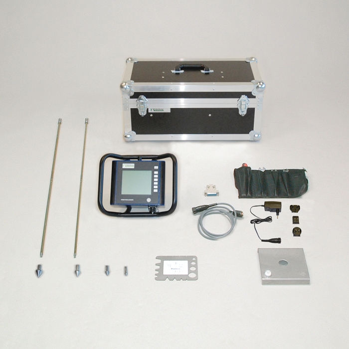
- The cone is screwed on the probing rod, which is connected with a quick coupling to the force sensor on the penetrologger. Now the cone is pushed slowly and regularly into the soil.
- The depth reference plate, which is on the soil surface, reflects the signals of the ultrasonic sensor, which results in very accurate depth measurement.
- The depth reference plate is also used to reflect the signals which are used to control the penetration speed.
- The measured resistance to penetration and the GPS coordinates are stored in the internal logger of the penetrologger.
| Angle of cone | 60 ° |
| Battery lifetime | 8 hours |
| Cone surface range | 1, 2, 3.3, 5 cm² |
| Connection | screwthread |
| Data output | .txt, other |
| Data plug type | RS232 |
| Data storage capacity | 1500 |
| Data transfer | cable |
| International Protection Rating | 54 |
| Maximum Applicable pressure | 10000 kPa |
| Maximum measuring depth | 0.80 m |
| Maximum operating temperature | 50 ° |
| Measured parameters | penetration resistance |
| Measuring accuracy | < ± 1% |
| Measuring range | 0...10000 kPa |
| Minimum operating temperature | 0 ° |
| Power supply | battery |
| Product material | stainless steel, iron, PVC, other material |
| Programming possibility | Yes |
| Reading accuracy | 0.1% |
| Registration type | logging |
| Package size | 60 x 30 x 24 cm |
| Weight | 15.5 kg |
The penetrologger can be applied in the agricultural as well as in the civil engineering sector:
- General soil science research;
- Foundation technology;
- Checking whether or not the soil is suitable for agricultural;
- Research into (expected) growing conditions for plants;
- The detection of compacted (possibly impermeable) sub-soil layers;
- Research into poor growing conditions of for instance trees in the city or in parks;
- Checking artificially-made compactions;
- Checking the suitability of soils for carrying vehicles or pedestrians.
- No mechanical parts, strong and reliable
- Incorporated fast GPS. Data are auto-stored
- Soil moisture indicator can be connected
- Record one moisture % per measurement
- Moisture recordings allow comparing of data
- 500 fully digital depth/force recordings
- Numerous different projects can be defined
- Projects can be selected at any moment
- Velocity indicator stimulates correct pushing
- Field and office programmable / read-out
- Will show, upload or print any reading
- Will show averages and spreading