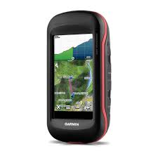
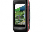
Garmin Montana® 680
- 4-inch dual-orientation, glove-friendly touchscreen display
- 8 megapixel autofocus camera; automatically geotags photos
- Tracks both GPS and GLONASS satellites
- 1-year BirdsEye Satellite Imagery subscription
- 3-axis compass with barometric altimeter
- Dispaly resolution: 272 x 480 pixels
- Weight: 289g with battery
- Battery: 3 AA batteries
- Water rating: IPX7
- Memory: 4 GB
- Way points: 4000
- Routes: 200
- Track log: 10000 points, 200 saved
| Physical dimensions | 2.9" x 5.7" x 1.4" (7.48 x 14.42 x 3.64 cm) |
| Display size, WxH | 2"W x 3.5"H (5.06 x 8.93 cm); 4" diag (10.2 cm) |
| Display resolution, WxH | 272 x 480 pixels |
| Display type | bright, transflective 65k color TFT, dual-orientation touchscreen; sunlight readable |
| Touchscreen | Yes |
| Weight |
10.2 oz (289 g) with included lithium-ion battery pack; 11.7 oz (333 g) with 3 AA batteries (not included) |
| Battery | rechargeable lithium-ion (included) or 3 AA batteries (not included); NiMH or Lithium recommended |
| Battery life | up to 16 hours (lithium-ion); up to 22 hours (AA batteries) |
| Water rating | IPX7 |
| High-sensitivity receiver | Yes |
| Interface | high-speed USB and NMEA 0183 compatible |
| Camera | Yes (8 megapixel with autofocus; automatic geo-tagging) |
| Barometric altimeter | Yes |
| Electronic compass | Yes (tilt-compensated 3-axis) |
| Unit-to-unit transfer (shares data wirelessly with similar units) | Yes |
| Maps & Memory | |
| Basemap | Yes |
| Ability to add maps | Yes |
| Built-in memory | 4 GB |
| Accepts data cards | microSD™ card (not included) |
| Custom POIs (ability to add additional points of interest) | Yes |
| Waypoints/favorites/locations | 4000 |
| Routes | 200 |
| Track log | 10,000 points, 200 saved tracks |